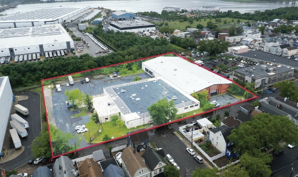
Middlesex County  »  08861  »  Walnut St  »  1 Walnut St

1 Walnut Street, Perth Amboy, NJ 08861 Property Information

1 Walnut Street, Perth Amboy, NJ 08861 Property Information

  • General
  • Owner
  • Documents
  • Tax
  • Neighborhood
Unlock this property report with a free account.

Access up-to-date information from property owner names to sales history, tax info, title documents, mortgages, development, maps, permits and more.
Sign Up Now
Research 100M+ property records powered by:
  • 2000+ governmental and public data sources
  • 80 dedicated analysts and researchers
  • 20+ years of real estate experience
Learn More

Photo & Map Show Hide

1 Walnut Street, Perth Amboy, NJ 08861
static Mapbox map

Address

Primary address 1 Walnut Street, Perth Amboy
Zip code 08861
County Middlesex
Municipality Perth Amboy City
Block 40
Lot 1.02

Sales & Tax Overview for 1 Walnut Street, Perth Amboy

View detailed information on past sales, title documents and property taxes, including the assessed market value, in their dedicated tabs.

Sale date 10/16/2019
Sale price $5,950,000
Arm's length
Current property tax $140,715

Lot & Building Information for 1 Walnut Street, Perth Amboy

Building sqft 56,696
Building class Industrial/Manufacturing (330)
Acreage 2.99
Year built 1968
Exterior structural material
Unlock this property report with a free account.

Access up-to-date information from property owner names to sales history, tax info, title documents, mortgages, development, maps, permits and more.
Sign Up Now

Zoning, Use & Area Overview

Walk Score
Transit Score
Bike Score


Zoning district
Broadband internet providers and speed map
Types of broadband connections map

View more neighborhood information such as transportation, nearby schools and risk designations in the dedicated tab.

Other Property Data for 1 Walnut Street, Perth Amboy

Property reports include comprehensive occupancy, improvement and development information (where available).
Create a free account to access valuable data points such as:

  • • Improvements for 1 Walnut Street, Perth Amboy , including their type, square footage, grade and when they were built.
  • Development maps such as planimetric, zoning, land use and urban landscape maps (building age and stories).
Unlock all property data with a free account.
Sign up

About 1 Walnut Street, Perth Amboy

How many sq. ft. does 1 Walnut Street, Perth Amboy, NJ 08861 have & what is the price per sq. ft?

This Industrial/Manufacturing (330) located at 1 Walnut Street, Perth Amboy, NJ 08861 has a total of 56,696 square feet and a current price per square foot of $104.

What is the year built & the current market value of 1 Walnut Street, Perth Amboy, NJ 08861?

1 Walnut Street, Perth Amboy, NJ 08861 was built in 1968 and has a current tax assessor's market value of $4,500,000.

Ownership Information

View detailed property contacts like owners, building management, representatives from permits and tenants with a free account.

Spaces for Sale in 1 Walnut Street, Perth Amboy

1 Walnut Street
Listing type For Sale
Listing date 07/17/2025
Last updated 05/01/2026

AAI-95 & NJ Tpke: 5 min | 1.8 miles EWR: 22 min | 16.5 miles Goethals Bridge: 27 min | 19.7 miles Newark/Elizabeth Port: 30 min | 17.5 miles G.W. Bridge: 48 min | 35.9 milesPRICING: Please Call To Inquire

View Listing

Brokers

Drew Maffey
Active Listings For This Property:
For Sale 1 Walnut Street
1 Walnut Street
1 Walnut Street, Perth Amboy
Property Warehouse/Distribution
Availability Spaces listed / Sqft
Price $0
Research 100M+ property records powered by:
  • 2000+ governmental and public data sources
  • 80 dedicated analysts and researchers
  • 20+ years of real estate experience
Learn More

Past Sales & Property History for 1 Walnut Street, Perth Amboy

Create a free account to view the complete sales history for 1 Walnut Street, Perth Amboy, including title documents, transfer conditions, mortgages and liens.

Purchase date Purchase price Buyer name Seller name
10/16/2019 $5,950,000

Title Documents for 1 Walnut Street, Perth Amboy

To view the complete history of deeds, mortgages, assignments of leases and rents, and more, sign up for free. Available data goes back to 1966.

Date Type Amount Party 1 Party 2 Maturity Index Document Related documents Doc image
07/18/2025 - D
07/22/2025 - R
Assignment
06/25/2025 - D
07/22/2025 - R
Assignment
04/05/2023 - D
04/17/2023 - R
Assignment
08/13/2020 - D
09/25/2020 - R
Assignment
08/13/2020 - D
09/22/2020 - R
Mortgage
08/13/2020 - D
09/22/2020 - R
Mortgage
07/29/2020 - D
08/07/2020 - R
Mortgage
07/29/2020 - D
08/07/2020 - R
Mortgage
07/28/2020 - D
10/26/2020 - R
Deed W/O Abstra No
07/28/2020 - D
08/07/2020 - R
Mortgage
Unlock title documents, including buyer and seller information (when available).
Sign up

R: Recorded date
D: Document date

Property Taxes for 1 Walnut Street, Perth Amboy

Access detailed property tax data for 1 Walnut Street, Perth Amboy, NJ 08861. Tax information included: property tax, market value and assessed value, exemptions, abatements, and assessment history.

Tax year: 2025
Base tax $135,765
Current property tax $140,715
Market value $4,500,000

Assessment History for 1 Walnut Street, Perth Amboy

Here's the assessment & property tax history for 1 Walnut Street, Perth Amboy, including the evolution of the total tax rate and corresponding property tax.

Year Market value Assessment value Total tax rate Property tax Year over year change
2024 $4,500,000 $4,500,000 3.017 $135,765 +0.20%
2023 $4,500,000 $4,500,000 3.011 $135,495 +1.21%
2022 $4,500,000 $4,500,000 2.975 $133,875 -0.13%
2021 $4,500,000 $4,500,000 2.979 $134,055 +0.03%
2020 $4,500,000 $4,500,000 2.978 $134,010 +44.63%

Demographics By Zip Code

Total population 58,264
Median age 37
Average household income $81,161
Family households 71.7%
Occupied housing units 20,367
Owner occupied units 35.0%
Average number of people per household 2
Median year structure built 1957
Median value for units with a mortgage $348,400
Median value for units without a mortgage $329,300

Risk

Create a free account to unlock extended information for 1 Walnut Street, Perth Amboy, including whether it's located in FEMA flood zones, floodways or special flood hazard areas, as well as the Coastal barriers resources system area (COBRA).

FEMA flood zone(s) X (See more on map)
Fire hazard zone See more on map
Geohazard zones map

Transportation

Access the detailed traffic volume map for 1 Walnut Street, Perth Amboy to see estimated average daily traffic on streets surrounding the property as well as the types of properties in its vicinity.

View daily traffic map

Neighbors for 1 Walnut Street, Perth Amboy

Here are the neighbors for 1 Walnut Street, Perth Amboy.

Address Square feet Purchase date Purchase price
174 2nd St, Perth Amboy 2,260 11/23/2021 $1,600,000
224 Gordon St, Perth Amboy 908 08/05/2022 $195,000
147 2nd St, Perth Amboy 8,398
190 2nd St, Perth Amboy 1,083 02/04/2020 $1
222 Gordon St, Perth Amboy 939 03/13/2020 $222,000
189-201 2nd St, Perth Amboy 19,872 11/29/2018 $3,650,000
156 2nd St, Perth Amboy 9,221 11/23/2021 $1,600,000
206 Gordon St, Perth Amboy 1,326 09/16/2014 $180,000
186 2nd St, Perth Amboy 1,128 07/16/1999 $70,000
1 Olive St, Perth Amboy 15,064
173 2nd St, Perth Amboy 08/21/2013 $165,000
218 Gordon St, Perth Amboy 1,408 08/29/2013 $175,000
216 Gordon St, Perth Amboy 1,368 11/30/2006 $1
208 Gordon St, Perth Amboy 1,552 05/18/2023 $262,500
233 Elm St, Perth Amboy 07/08/2005 $13,670,000
212 Gordon St, Perth Amboy 1,760 06/10/2025 $300,000
220 Gordon St, Perth Amboy 1,728 02/15/2025 $1
210 Gordon St, Perth Amboy 2,160 11/17/2021 $405,000
144 Grant St, Perth Amboy 64,172 03/28/2018 $4,600,000

Nearby ZIP Codes for 1 Walnut Street, Perth Amboy

Not sure if we cover all the data-points you need? View sample full report View sample full report