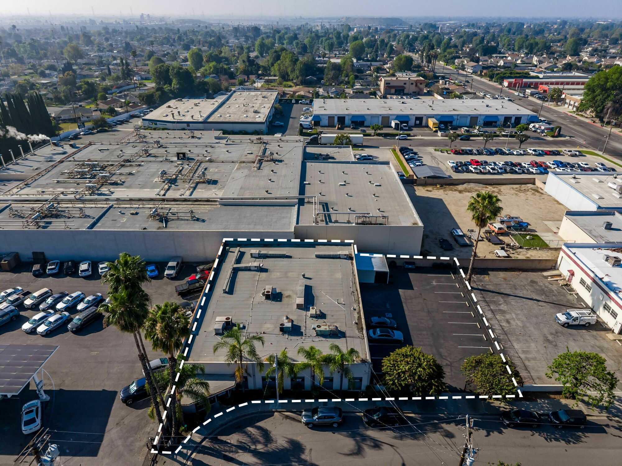
260 Taylor Street, Monrovia, CA 91016 Property Information
- General
- Owner
- Documents
- Tax
- Permits
- Neighborhood
Address
| Primary address | 260 Taylor Street, Monrovia |
| Zip code | 91016 |
| County | Los Angeles |
| Municipality | Monrovia |
Sales & Tax Overview for 260 Taylor Street, Monrovia
View detailed information on past sales, title documents and property taxes, including the assessed market value, in their dedicated tabs.
| Current property tax | $5,595 |
Lot & Building Information for 260 Taylor Street, Monrovia
| Building sqft | 8,208 |
| Building class | Warehouse |
| Acreage | 0.336
|
| Year built | 1961 |
| Year last altered | 1977 |
Zoning, Use & Area Overview
| Zoning district | Register |
| Weed hazard | No |
| School district | Monrovia Unified School District |
View more neighborhood information such as transportation, nearby schools and risk designations in the dedicated tab. For more property insights, including its Energy Star score, its Existing Buildings Energy and Water Efficiency Program (EBEWE) status, and additional energy and water usage data, create an account.
Other Property Data for 260 Taylor Street, Monrovia
Property reports include comprehensive occupancy, improvement and development information (where available).
Create a free account to access valuable data points such as:
- • Improvements for 260 Taylor Street, Monrovia , including their type, square footage, grade and when they were built.
- • Development maps such as planimetric, zoning, land use and urban landscape maps (building age and stories).
Sign up
About 260 Taylor Street, Monrovia
This Warehouse (SCILSI) located at 260 Taylor Street, Monrovia, CA 91016 has a total of 8,208 square feet.
What is the year built & the current market value of 260 Taylor Street, Monrovia, CA 91016?260 Taylor Street, Monrovia, CA 91016 was built in 1961 and has a current tax assessor's market value of $276,769.
Ownership Information
View detailed property contacts like owners, building management, representatives from permits and tenants with a free account.
Spaces for Sale in 260 Taylor Street, Monrovia
| Listing type | For Sale |
|---|---|
| Listing date | 05/11/2026 |
| Last updated | 05/19/2026 |
| Lot size | 0.3359 Acre |
Built in 1960 and located in the highly desirable, industrial submarket of the Upper San Gabriel Valley.This ±8,538 SF property provides convenient access to Interstate 210 (I-210) and the broader Los Angeles metro area. Located in an established, inï¬ll submarket with limited new supply, the oï¬ering presents an attractive proï¬le for buyers seeking reliable cash ï¬ow and long-term value in Southern California.
Brokers
Past Sales & Property History for 260 Taylor Street, Monrovia
Create a free account to view the complete sales history for 260 Taylor Street, Monrovia, including title documents, transfer conditions, mortgages and liens.
No recorded sales for this property.
Title Documents for 260 Taylor Street, Monrovia
To view the complete history of deeds, mortgages, assignments of leases and rents, and more, sign up for free. Available data goes back to 1966.
Sign up
R: Recorded date
D: Document date
Property Taxes for 260 Taylor Street, Monrovia
Access detailed property tax data for 260 Taylor Street, Monrovia, CA 91016. Tax information included: property tax, market value and assessed value, exemptions, abatements, and assessment history.
| Tax year: | 2025-2026 |
| Base tax | $3,556 |
| Current property tax | $5,595 |
| Market value | $276,769 |
Special Assessments And Penalties for 260 Taylor Street, Monrovia
Special Assessments
Abatements, financial assistance programs and non-ad valorem taxes levied as special taxes/direct assessments are applicable for this property.
| Code | Description | Tax levied |
|---|---|---|
| 06215 | County Sanitation District #15 | Register |
| 03694 | La County Regional Park And Open Space District | Register |
| 03071 | Los Angeles County Flood Control | Register |
| 00170 | Los Angeles County Trauma/Emerg Srvs | Register |
| 21297 | Monrovia Ldscp & Light Maintenance District | Register |
Assessment History for 260 Taylor Street, Monrovia
Here's the assessment & property tax history for 260 Taylor Street, Monrovia, including the evolution of the total tax rate and corresponding property tax.
| Year | Assessment value | Total tax rate | Property tax | Year over year change |
|---|---|---|---|---|
| 2025-2026 | $276,769 | 1.285 | $3,556 | +2.25% |
| 2024-2025 | $271,343 | 1.2818 | $3,478 | +2.42% |
| 2023-2024 | $266,023 | 1.2765 | $3,396 | +3.10% |
| 2022-2023 | $260,807 | 1.2629 | $3,294 | +1.94% |
| 2021-2022 | $255,694 | 1.2638 | $3,231 | +3.34% |
Permits for 260 Taylor Street, Monrovia
The complete history of permits filed for 260 Taylor Street, Monrovia, including new construction or demolition permits, complaints, plus any work pertaining to plumbing, heating and sprinkler systems is available with a free account. Available data goes back to 1990.
Sign up
Monrovia residential market stats
Access a detailed real estate market overview of Monrovia so you can assess current trends, home values, types of properties sold and transaction volume. View the median home sale price in Monrovia and compare it to other neighborhoods in Los Angeles County.
Check out recently sold homes in Monrovia and see how their prices compare.
Demographics by Zip Code
| Total population | 41,140 |
| Median age | 38.4 |
| Average household income | $126,522 |
| Family households | 66.2% |
| Occupied housing units | 15,285 |
| Owner occupied units | 48.0% |
| Average number of people per household | 2.68 |
| Median year structure built | 1961 |
| Median value for units with a mortgage | $910,300 |
| Median value for units without a mortgage | $862,700 |
Risk
Create a free account to unlock extended information for 260 Taylor Street, Monrovia, including whether it's located in FEMA flood zones, floodways or special flood hazard areas, as well as the Coastal barriers resources system area (COBRA).
| FEMA flood zone(s) | X (See more on map) |
| Fire hazard zone | See more on map |
| Faults and tsunami inundation zone map | Register |
| Landslides and liquefaction map | Register |
Transportation
Access the detailed traffic volume map for 260 Taylor Street, Monrovia to see estimated average daily traffic on streets surrounding the property as well as the types of properties in its vicinity.
| View daily traffic map |
Neighbors for 260 Taylor Street, Monrovia
Here are the neighbors for 260 Taylor Street, Monrovia.
| Address | Square feet | Purchase date | Purchase price |
|---|---|---|---|
| 1827 S Myrtle Ave, Monrovia | 2,236 | 11/28/2001 | |
| 1900 S Myrtle Ave, Monrovia | 7,667 | 02/05/2014 | $1,269,000 |
| 1819 S Myrtle Ave, Monrovia | 5,400 | 11/28/2001 | |
| 1911 Walker Ave, Monrovia | 19,200 | 02/05/2014 | $3,806,500 |
| 140 E Duarte Rd, Monrovia | 16,200 | 05/06/2013 | $7,490,000 |
| 1960 Walker Ave, Monrovia | 26,176 | 12/05/2024 | |
| 1938 S Myrtle Ave, Monrovia | 4,000 | 06/30/2022 | $750,000 |
| 1820 S Myrtle Ave, Monrovia | 15,000 | 05/06/2013 | $7,490,000 |
| 110 E Duarte Rd, Monrovia | 10,275 | 10/22/2004 | |
| 1835 S Myrtle Ave, Monrovia | 1,225 | 03/11/2024 | |
| 1941 Walker Ave, Monrovia | 26,000 | 12/24/2020 | |
| 2000 S Myrtle Ave, Monrovia | 7,440 | 02/05/2014 | $975,000 |
| 1924 S Myrtle Ave, Monrovia | 8,385 | 03/06/2019 | $1,000,000 |
| 1942 S Myrtle Ave, Monrovia | 6,670 | 07/22/2014 | $1,025,000 |
| 100 W Duarte Rd, Monrovia | 7,244 | 04/26/2013 | $2,050,000 |
| 1900 Walker Ave, Monrovia | 24,900 | 12/29/2023 | |
| 220 Taylor St, Monrovia | 6,039 | 12/05/2024 | |
| 1803 S Myrtle Ave, Monrovia | 8,300 | 01/24/2008 | $1,400,000 |
| 1930 Walker Ave, Monrovia | 14,003 | 10/06/2021 | |
| 1811 S Myrtle Ave, Monrovia | 5,200 | 11/28/2001 |