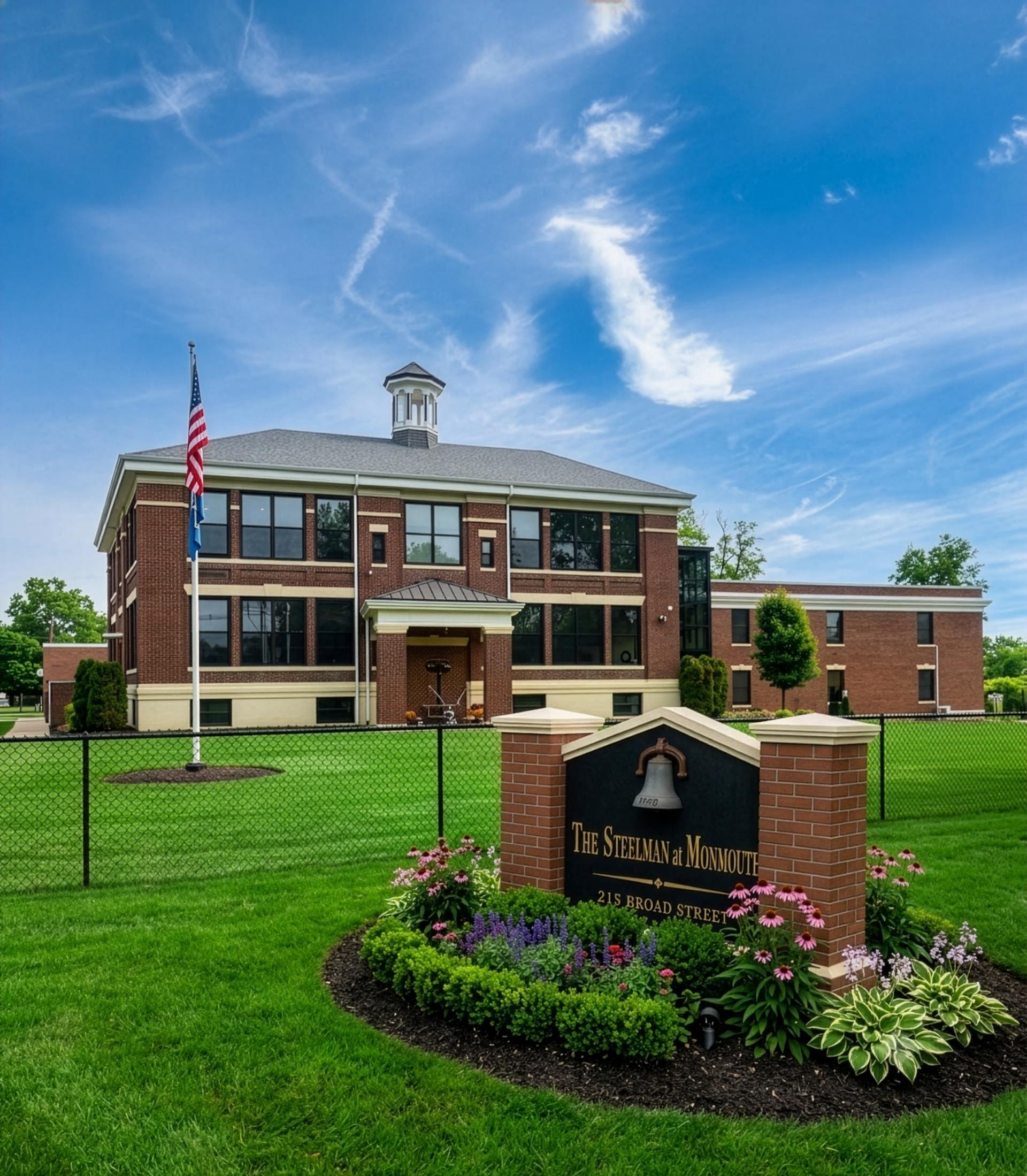
Monmouth County  »  07724  »  Broad St  »  215 Broad St

215 Broad Street, Eatontown, NJ 07724 Property Information

215 Broad Street, Eatontown, NJ 07724 Property Information

  • General
  • Owner
  • Documents
  • Tax
  • Neighborhood
Unlock this property report with a free account.

Access up-to-date information from property owner names to sales history, tax info, title documents, mortgages, development, maps, permits and more.
Sign Up Now
Research 100M+ property records powered by:
  • 2000+ governmental and public data sources
  • 80 dedicated analysts and researchers
  • 20+ years of real estate experience
Learn More

Photo & Map Show Hide

215 Broad Street, Eatontown, NJ 07724
static Mapbox map

Address

Primary address 215 Broad Street, Eatontown
Zip code 07724
County Monmouth
Municipality Eatontown Borough
Block 301
Lot 51

Sales & Tax Overview for 215 Broad Street, Eatontown

View detailed information on past sales, title documents and property taxes, including the assessed market value, in their dedicated tabs.

Sale date 11/17/2025
Sale price $1,000
Arm's length
Property tax $54,445

Lot & Building Information for 215 Broad Street, Eatontown

Building sqft 14,482
Building class Office Building
Acreage 2.07
Year built 1900
Unlock this property report with a free account.

Access up-to-date information from property owner names to sales history, tax info, title documents, mortgages, development, maps, permits and more.
Sign Up Now

Zoning, Use & Area Overview

Walk Score
Transit Score
Bike Score


Zoning district
Broadband internet providers and speed map
Types of broadband connections map

View more neighborhood information such as transportation, nearby schools and risk designations in the dedicated tab.

Other Property Data for 215 Broad Street, Eatontown

Property reports include comprehensive occupancy, improvement and development information (where available).
Create a free account to access valuable data points such as:

  • • Improvements for 215 Broad Street, Eatontown , including their type, square footage, grade and when they were built.
  • Development maps such as planimetric, zoning, land use and urban landscape maps (building age and stories).
Unlock all property data with a free account.
Sign up

About 215 Broad Street, Eatontown

How many sq. ft. does 215 Broad Street, Eatontown, NJ 07724 have & what is the price per sq. ft?

This Office Building (SCILSO) located at 215 Broad Street, Eatontown, NJ 07724 has a total of 14,482 square feet and a current price per square foot of $0.

What is the year built & the current market value of 215 Broad Street, Eatontown, NJ 07724?

215 Broad Street, Eatontown, NJ 07724 was built in 1900 and has a current tax assessor's market value of $3,097,000.

Ownership Information

View detailed property contacts like owners, building management, representatives from permits and tenants with a free account.

Spaces for Lease in 215 Broad Street, Eatontown

No photo available
Ready to grow? Your ideal location is closer than you think in Eatontown, NJ
Listing type For Lease
Listing date 05/07/2024
Last updated 05/14/2026

Commercial space suitable for medical or general office use

View Listing

Brokers

Chidi Egesionu
Douglas Twyman
Spaces
Suite name Space type Lease rate Available space Brokers
Space Available General Office Listing price not available 5,000 Chidi Egesionu
Douglas Twyman
Active Listings For This Property:
For Lease No photo available
Ready to grow? Your ideal location is closer than you think in Eatontown, NJ
215 Broad Street, Eatontown
Property General Office
Availability 1 Spaces listed / 5000 Sqft
Price Listing price not available
Research 100M+ property records powered by:
  • 2000+ governmental and public data sources
  • 80 dedicated analysts and researchers
  • 20+ years of real estate experience
Learn More

Past Sales & Property History for 215 Broad Street, Eatontown

Create a free account to view the complete sales history for 215 Broad Street, Eatontown, including title documents, transfer conditions, mortgages and liens.

Purchase date Purchase price Buyer name Seller name
11/17/2025 $1,000
08/03/2021 $2,725,000
12/31/2014 $768,000
       
       
Access the complete sales history for 215 Broad Street, Eatontown with a free account.
Sign up

*Here are the three most recent sales for this property.


Title Documents for 215 Broad Street, Eatontown

To view the complete history of deeds, mortgages, assignments of leases and rents, and more, sign up for free. Available data goes back to 1966.

Date Type Amount Party 1 Party 2 Maturity Index Document Related documents Doc image
11/17/2025 - D
12/01/2025 - R
Deeds from 10/01/1996 to Present
11/03/2025 - R Mortgage Assignment of Leases & Rents
07/10/2025 - D
07/16/2025 - R
Mortgage
11/22/2021 - R
11/22/2021 - R
09/13/2021 - R Mortgage Assignment of Leases & Rents
08/03/2021 - D
09/13/2021 - R
Mortgage
08/03/2021 - D
09/13/2021 - R
Deeds from 10/01/1996 to Present
02/21/2019 - D
02/26/2019 - R
Mortgage
12/31/2014 - D
01/08/2015 - R
Deed and Realty Tax Fees
Unlock title documents, including buyer and seller information (when available).
Sign up

R: Recorded date
D: Document date

Property Taxes for 215 Broad Street, Eatontown

Access detailed property tax data for 215 Broad Street, Eatontown, NJ 07724. Tax information included: property tax, market value and assessed value, exemptions, abatements, and assessment history.

Tax year: 2025
Property tax $54,445
Market value $3,097,000

Assessment History for 215 Broad Street, Eatontown

Here's the assessment & property tax history for 215 Broad Street, Eatontown, including the evolution of the total tax rate and corresponding property tax.

Year Market value Assessment value Total tax rate Property tax Year over year change
2025 $3,097,000 $3,097,000 1.758 $54,445 -4.82%
2024 $3,055,600 $3,055,600 1.872 $57,201 +4.54%
2023 $2,776,100 $2,776,100 1.971 $54,717 +10.73%
2022 $2,276,100 $2,276,100 2.171 $49,414 +176.83%
2021 $776,100 $776,100 2.3 $17,850 +0.88%

Demographics by Zip Code

Total population 24,016
Median age 47.6
Average household income $142,501
Family households 64.4%
Occupied housing units 9,853
Owner occupied units 71.8%
Average number of people per household 2.41
Median year structure built 1973
Median value for units with a mortgage $542,200
Median value for units without a mortgage $475,100

Risk

Create a free account to unlock extended information for 215 Broad Street, Eatontown, including whether it's located in FEMA flood zones, floodways or special flood hazard areas, as well as the Coastal barriers resources system area (COBRA).

FEMA flood zone(s) X (See more on map)
Fire hazard zone See more on map
Geohazard zones map

Transportation

Access the detailed traffic volume map for 215 Broad Street, Eatontown to see estimated average daily traffic on streets surrounding the property as well as the types of properties in its vicinity.

View daily traffic map

Neighbors for 215 Broad Street, Eatontown

Here are the neighbors for 215 Broad Street, Eatontown.

Address Square feet Purchase date Purchase price
2 Rose CT, Eatontown 1,609 04/16/2013 $1
64 Rose CT, Eatontown 1,340 11/27/2021 $148,450
52 College Ave, Eatontown 1,256 01/29/2009 $1
2 Academy Ave, Eatontown 1,488 06/09/2009 $1
29 Rose CT, Eatontown 2,008 09/20/2023 $537,000
30 College Ave, Eatontown 2,512
95 College Ave, Eatontown 1,604
4 Rose CT, Eatontown 1,348 06/14/2022 $229,900
52 Rose CT, Eatontown 1,176 04/08/2014 $263,000
35 Rose CT, Eatontown 1,540 08/07/2013 $330,000
44 College Ave, Eatontown 1,352 12/14/1977 $30,000
58 Rose CT, Eatontown 2,192 06/24/2014 $250,000
163 Broad St, Eatontown 2,264 01/01/2021 $1
25 Rose CT, Eatontown 1,545 10/17/2008 $327,500
41 Rose CT, Eatontown 2,164 03/03/2003 $264,000
47 Rose CT, Eatontown 1,344 07/11/2012 $281,000
53 Rose CT, Eatontown 1,344 10/30/2015 $1
59 Rose CT, Eatontown 1,344 06/24/1994 $151,000
3 Rose CT, Eatontown 1,898 03/18/2015 $370,000
29 College Ave, Eatontown 1,860 06/11/2025 $1

Nearby ZIP Codes for 215 Broad Street, Eatontown

Not sure if we cover all the data-points you need? View sample full report View sample full report