

New York Real Estate | 5 minute read
How to Find Property Lines by Address — Free & Paid Tools
By Laura Pop-Badiu | Feb 12, 2026
Understanding where a property begins and ends is critical in real estate because property lines define ownership, rights and responsibilities. In this guide, you'll learn the exact steps of finding property lines by address, by using free methods, as well as paid tools.
Understanding where a property begins and ends is critical in real estate because property lines define ownership, rights and responsibilities. Whether you’re buying, selling, developing or managing property, inaccurate assumptions about boundaries can lead to costly disputes, permitting delays, zoning violations or even legal action. Additionally, for buyers and investors, verifying boundaries helps confirm lot size, usable land and compliance with local regulations — key factors that directly affect value and risk.
To find property lines by address, start with your local free parcel or GIS viewer — usually maintained by your county assessor or the county planning or GIS department — or go straight to a premium real estate data platform, like PropertyShark. County parcel boundary maps will typically show approximate parcel boundaries; lot dimensions or boundary shape; ownership; the assessor’s parcel number (APN) which may be called a parcel ID, tax ID, AIN or PIN, depending on your location; and basic tax, zoning and property type information.
However, when legal accuracy is required — such as for construction, permitting or resolving a boundary dispute — a licensed land surveyor is the only authoritative option.
In short, these are the most essential steps to find property lines by address:
1. Search your address in a county parcel viewer (free) or PropertyShark (paid).
2. View the parcel overlay to see approximate boundaries and lot dimensions.
3. Confirm boundary descriptions using your deed or a recorded plat map.
4. Hire a licensed surveyor if you need legally binding boundaries.
What Are Property Lines?
Property lines — also referred to as property boundaries — are the specific legal boundaries of an individual parcel of land that define the extent of private ownership. They’re legally established by recorded deeds, plats and surveys.
When you’re looking to find property lines, it’s important to keep in mind that while maps can show boundary lines visually, only recorded documents and licensed surveys establish boundaries with true legal authority.
Step by Step: How to Find Property Lines by Address
Option 1 — Free Methods: County Parcel / GIS Viewers / PropertyShark
Most U.S. counties provide free online parcel or geographic information system (GIS) viewers through the assessor or planning department.
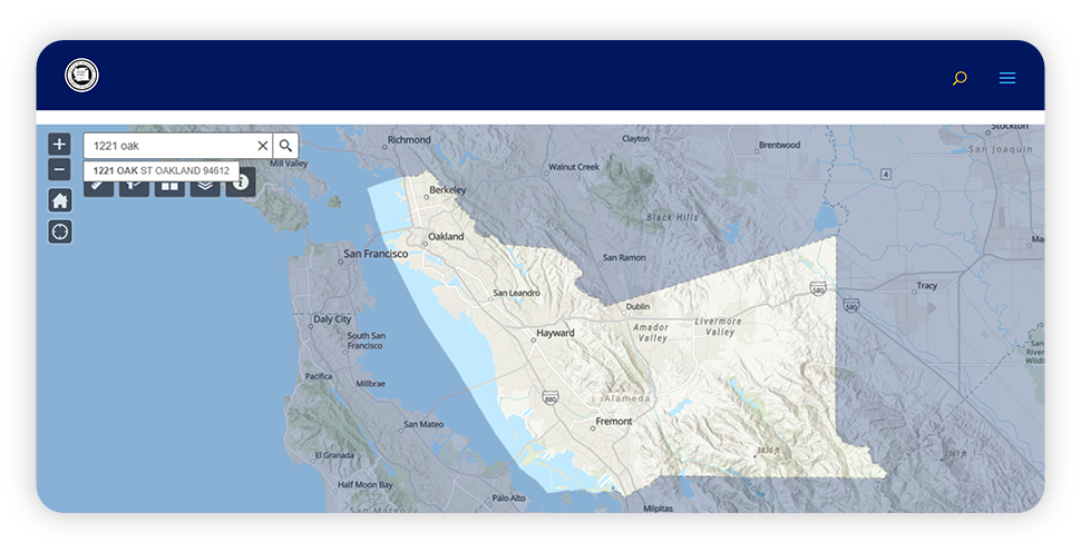
To exemplify this process step-by-step, we used the Alameda County Office of the Assessor Parcel Viewer. The process of finding property lines with this and other similar free tools typically works as follows:
- Go to the county assessor’s website and launch the county’s parcel or GIS viewer.
- Enter the street address or APN. In some cases, you can also search by condo name. Many tools offer auto-complete to help identify matching parcels.
- Select the correct address or APN from the results.
- The map will zoom to the parcel and display a parcel information pop-up.
- Use the built-in tools to view lot dimensions or parcel geometry, acreage and basic ownership data. Some parcel viewers will feature built-in aerial or street maps and may even include links to external map services like Google Maps or Street View. Other displayed data will often include property tax information as well as a detail panel or popup with attribute fields, commonly known as a parcel detail page.
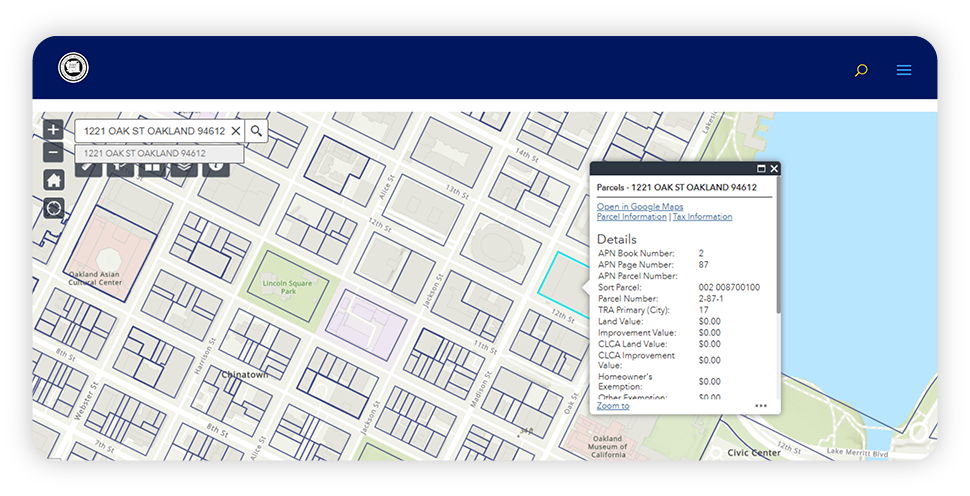
Limitations: County GIS maps are intended for reference purposes only, as boundary lines are approximate and may not reflect surveyed conditions.
Beyond the county parcel viewer, a free PropertyShark account offers an additional method of finding property lines by address, where users can see the parcel outline on map even without logging in. However, by creating a free account, users can access additional information on their target property — like lot dimensions — which can be useful for thorough due diligence.
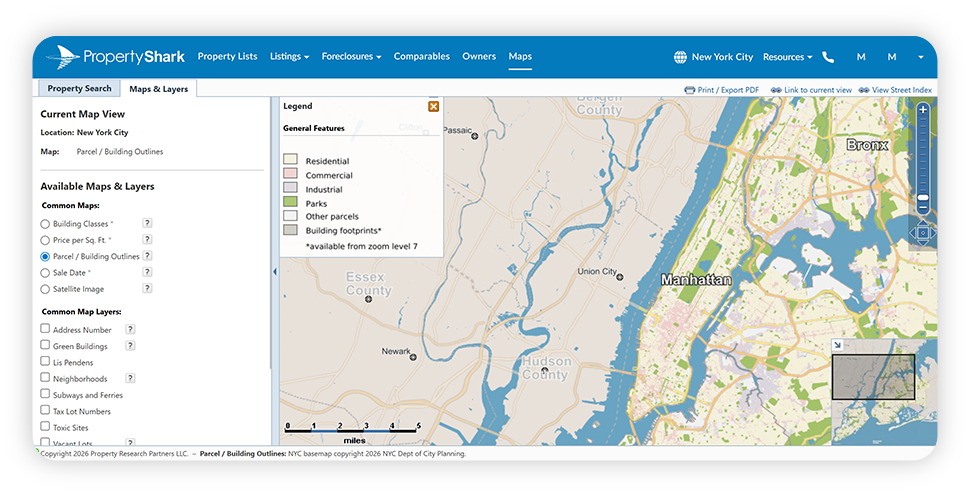
Option 2 — Premium Method: Find Property Lines Online Using PropertyShark
PropertyShark provides nationwide parcel data combined with a wide range of map layers, real estate research tools and property reports, making it a reliable and efficient method for finding property lines by address.
Find Property Boundaries Step by Step with PropertyShark
- Go to PropertyShark.com and create an account: You can choose between a free account for limited access or choose a subscription for full access.
- Click on the Maps tab, then select Property Search.
- Enter the property address or parcel ID.
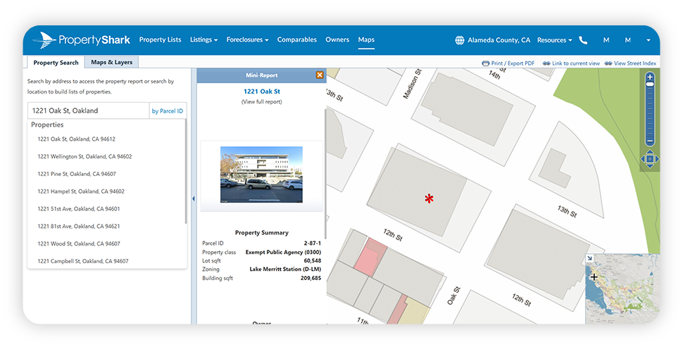
- Select the Parcel / Building Outlines map layer to display property lines.
- Explore additional premium maps included in your subscription. These will help you get more information on that property, by viewing zoning layers, opportunity zones or parcel feature maps among many other dynamic map layers.
- Quick inspect the mini property report, which typically includes lot size and dimensions, building square footage and property classification.
- Export or print the map with parcel boundaries for reference.
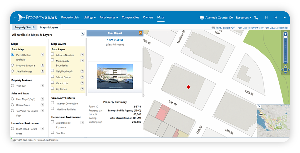
Tip: Open the full property report for deeper insights, including ownership history, transaction records, zoning details and financial data.
Why Use a Paid Tool Like PropertyShark?
While definitely useful when looking to find property lines by address, free county GIS tools vary widely in functionality and depth of information. In contrast, PropertyShark consolidates parcel data with zoning, ownership and market information in a standardized interface, making it a more reliable and efficient method of finding accurate property lines.
Paid tools like PropertyShark are especially useful for:
- Real estate investors
- Agents and brokers
- Developers and planners
- Buyers performing due diligence
Free vs. Paid Tools vs. Surveyors
| Feature | County GIS (Free) | PropertyShark (Paid) | Licensed Surveyor |
| Approximate property lines | ✔ | ✔ | ✔ |
| Legal boundary determination | ✖ | ✖ | ✔ |
| Lot dimensions & area | Limited | ✔ | ✔ |
| Ownership & deed access | Limited | ✔ | ✔ |
| Zoning & overlays | Limited | ✔ | ✔ |
| Printable reports | Limited | ✔ | ✔ |
| Accepted for permits or disputes | ✖ | ✖ | ✔ |

Research property boundaries with PropertyShark.
When Must You Hire a Surveyor
When looking to find property lines online, it’s important to remember that free and paid mapping tools are not legally binding. Instead, you must hire a licensed land surveyor when:
- Building fences, additions, garages or driveways
- Applying for construction permits or financing
- Resolving boundary disputes with neighbors
- Subdividing, selling or refinancing land
- Establishing easements or rights-of-way.
Always remember, that only a surveyor can legally establish or confirm property boundaries.
FAQs
What are property lines?
Property lines are the legal boundaries that define where a piece of real estate begins and ends. They determine land ownership, lot size, and where structures can be built, and are officially established through deeds, plats and land surveys.
Can I find property lines for free?
Yes, most counties offer free parcel or GIS viewers that you can use to search by address and view approximate property boundaries.
Is PropertyShark accurate for property lines?
PropertyShark provides reliable parcel data sourced from public records. But, like all mapping tools, boundaries are approximate and not a substitute for a survey.
About PropertyShark
PropertyShark is an online real estate database and property research tool that provides building details, ownership information, comparable sales and foreclosure data. Founded in 2003, PropertyShark serves real estate professionals and consumers in New York and other major U.S. markets.
Fair Use & Redistribution
We encourage and freely grant permission to reuse and repost information, analysis, charts, tables and images included on this page. When doing so, we only ask that you link back to this page or PropertyShark.com as the official source.
Disclaimer
Information provided on this page is purely informational and is not and should not be regarded as investment advice.
Access comprehensive property data and ownership information with intuitive research tools.

Laura Pop-Badiu is a Senior Creative Writer at PropertyShark, with a degree in Journalism and a background in both hospitality and real estate. Laura is a certified bookworm with a genuine passion for the written word and a keen interest in the real estate market, having previously written for Yardi's RentCafe, CoworkingCafe and CoworkingMag. Her work has been featured in major publications like The New York Times, Forbes, NBC News, The Business Journals, Chicago Tribune, MSN and Yahoo! Finance, among others.
Recent Reports

Locked-In Owners, Mobile Renters: Homeowners Stay Put as Renters Move 3.7x More Across Largest U.S. Cities
Renters became the primary drivers of long-distance mobility across the largest U.S. cities, moving 3.7 times more than owners in 2024, as high mortgage rates and housing costs kept many homeowners in place.

$4.6M Hudson Yards Maintains Top Spot, Luxury Sales in Malba Set $2.5M Price Record for Queens
Despite prices declining, Hudson Yards remained the most expensive NYC neighborhood, but TriBeCa’s growth closed the gap to under $400,000, while Malba set a new historic price record for Queens at $2.5 million, securing the highest ranking ever for the borough at #5.

2026 Q1 Foreclosure Report: Brooklyn Filings Fall Sharply, Bronx & Staten Island Hit New Peaks
Behind a deceptively mild citywide downtick, borough foreclosure markets pulled into significantly diverging paths as Brooklyn cases were nearly halved and the Bronx hit a new, record high. Meanwhile, Queens remained unchanged, Staten Island surged back up and Manhattan cooled slowly.