
PropertyShark was named by Time
"one of the best 50 websites of 2009"

New York Real Estate
- NYC Property Search
- NYC Property Values
- NYC Foreclosures
- NYC Property Owners
- NYC Property Records Search
- NYC Lis Pendens
Other New York Maps
Hazards, Environment, and Regulatory Maps of New York
- Fema Flood Zone Map
- Hurricane Evacuation Zones
- Toxic Sites
- HPD Violations Map
- Liquor License Prohibited Regions
- Restaurant Violations Map
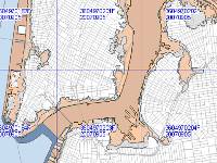
NYC Fema Flood Zone Map
The map displays areas in New York City that pose risk of flooding. The areas are divided into three risk categories: moderate- to low-risk areas, high-risk areas, and high-risk coastal areas.

NYC Hurricane Evacuation Zones
This map displays three hurricane evacuation zones that represent levels of threat of substantial coastal flooding caused by storm.
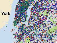
NYC Toxic Sites Map
If you want to know how "toxic" your neighborhood is, check out this map. It shows whether there is a toxic site such as a tank spill nearby a property.
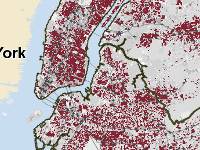
NYC HPD Violations Map
The map color-codes rental buildings based on the buildings' numbers of active violations.
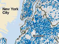
NYC Liquor License Prohibited Regions
View regions in New York City where a liquor license is prohibited by law. Most areas are in the close vicinity of schools or places of worship.
NYC Restaurant Violations Map
All restaurants in New York that have or have had an open violation are mapped. Check out whether your favorite restaurant is on the map.