

New York Real Estate | 6 minute read
How to Find Land Boundaries: Free & Paid Methods
By Laura Pop-Badiu | May 21, 2026
If you need to find land boundaries fast, you can start with a free county parcel/GIS viewer or a premium platform like PropertyShark to see an approximate parcel outline and lot data. However, keep in mind that a web-based land boundaries map is a starting point, not the legal finish line.
If you need to find land boundaries fast, you can start with a free county parcel/GIS viewer or a premium platform like PropertyShark to see an approximate parcel outline and lot data. However, keep in mind that a web-based land boundaries map is a starting point, not the legal finish line.
To ensure accuracy, confirm what you see on web-based land boundaries maps against the deed, the recorded plat and any recorded survey. If the answer to your land boundary questions need to hold up for a fence, shed, addition, permit, sale, subdivision or dispute, the best thing to do is to hire a licensed land surveyor.
What Land Boundaries Actually Are
A land boundary is the legal limit of a parcel. In cadastral terms, a cadastre is the public record, survey or map of the value, extent and ownership and usage of land. Cadastral data includes survey measurements, land interest transactions, general property descriptions, plus boundary and corner evidence. In short, while a web map may help you see land boundaries, the boundary itself is grounded in recorded documents and survey evidence.
Land boundaries and land property lines are sometimes used interchangeably, which is usually fine in casual conversation. However, the legal point matters: The controlling boundary is established by deeds, plats, surveys and monuments on the ground.
Step by Step: How to Find Land Boundaries Online
Free Method: County or City GIS / Parcel Viewer
When trying to find land boundaries, a county parcel viewer is the best free place to start. County-level jurisdictions typically provide online parcel viewers, with parcel-viewer data usually coming from county assessor databases. These tools are useful when you want to see land boundaries online, check a parcel number or compare the lot with roads, streams and nearby parcels.
To get started on this process, consider the following steps:
- Search your county name plus parcel viewer, GIS map or assessor parcel map.
- Enter the street address or parcel/APN number.
- Turn on parcel lines, lot lines or assessor parcel boundaries and explore the different types of map layers available.
- Save or print the map if the viewer offers export tools.
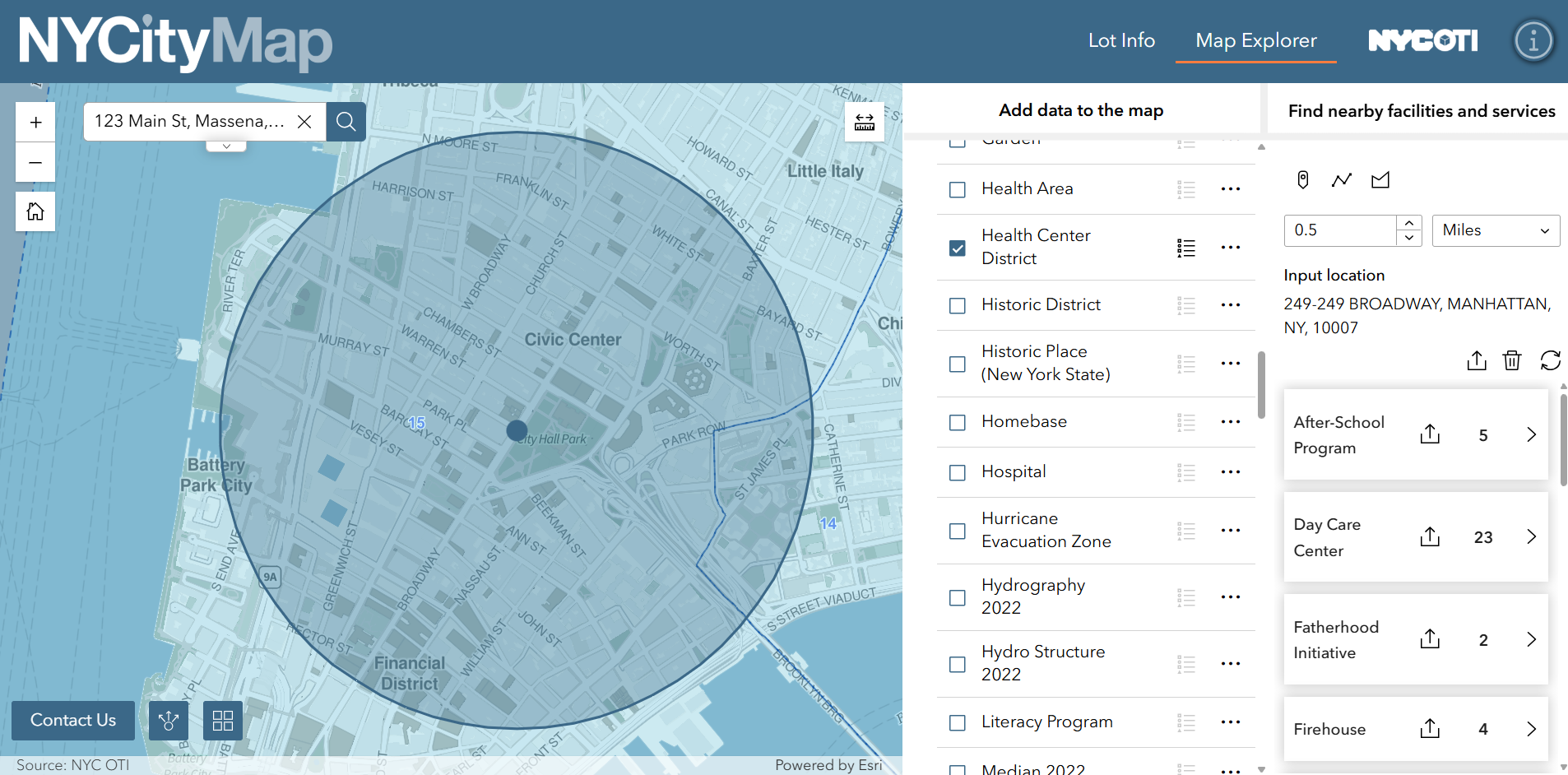
These insights are useful when trying to determine land boundaries, but it’s important to keep the result in perspective and know that counties routinely warn that assessor parcel maps are for assessment or informational use and do not represent a survey. While they may be compiled from deeds and surveys, they are still not the same thing as a legal boundary survey.
If you want a second checkpoint, PropertyShark also offers a free account path for limited research, which allows users to open one complete property report. Keep in mind that map access can be limited without a subscription and data depth can vary by region.
Premium Method: PropertyShark
If you want a faster research path, a PropertyShark account provides parcel maps, documents and property data, all in one place. The map tool allows users to search by address or parcel ID, add specific map layers and open a summarized report.
To leverage the PropertyShark Maps tool, use this workflow:
- Go to PropertyShark.com and create a free account or purchase a subscription.
- From the menu, click Maps, then Property Search.
- Enter the property address or parcel ID.
- Select Parcel / Building Outlines in the Maps & Layers tab to display land property lines.
- Switch to Satellite Image to visually inspect terrain features such as rivers or ridgelines that may help you interpret the site, while remembering that imagery is still not a legal boundary source.
- Explore additional map layers — including zoning and other available overlays — to understand how the parcel sits in its broader context.
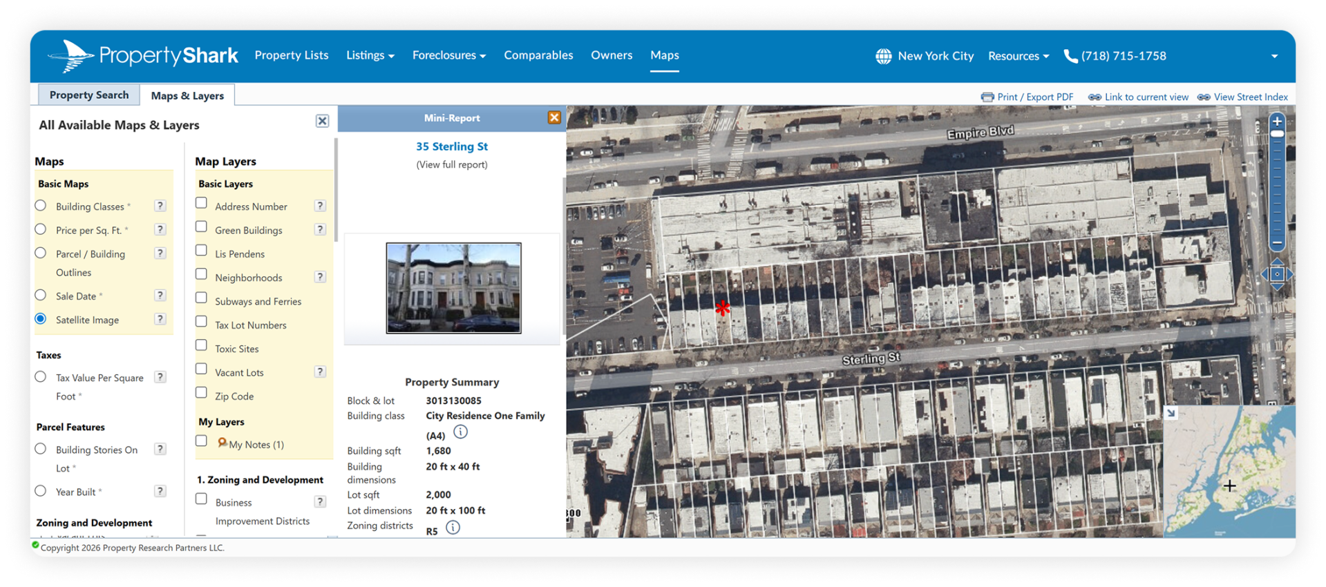
- Click the map pin to open the summarized report, which typically shows details such as property type, year built, building square footage, ownership and property tax data.
- Open the full property report for deed history, owners, zoning, lot size, lot dimensions and building shape diagrams where available.
- Export or print the map for working notes or documentation.
Pro Tip: Open the full property report to see ground elevation information, which will give you a better picture of the terrain. You can also use the full report for more comprehensive information, including ownership and financial details.
How to Read the Record That Define Boundaries
1. Deed Legal Description
The deed is where the legal description usually starts. PropertyShark’s title-search workflow lets you search by address or parcel ID, open the property report and review the Documents tab for deeds and other recorded documents. County clerks and recorders are the official repositories for recorded deed information and land records.
Use the deed to verify the parcel you are looking at on the map. If the deed is a lot-and-block description, match it to the recorded plat. If it is metes and bounds, compare the bearings, distances and referenced monuments to the survey or plat — not just to the web map. Also note that deed indexes are often organized by grantee name (buyer) rather than property address, so address-only searching is not always enough in public records.
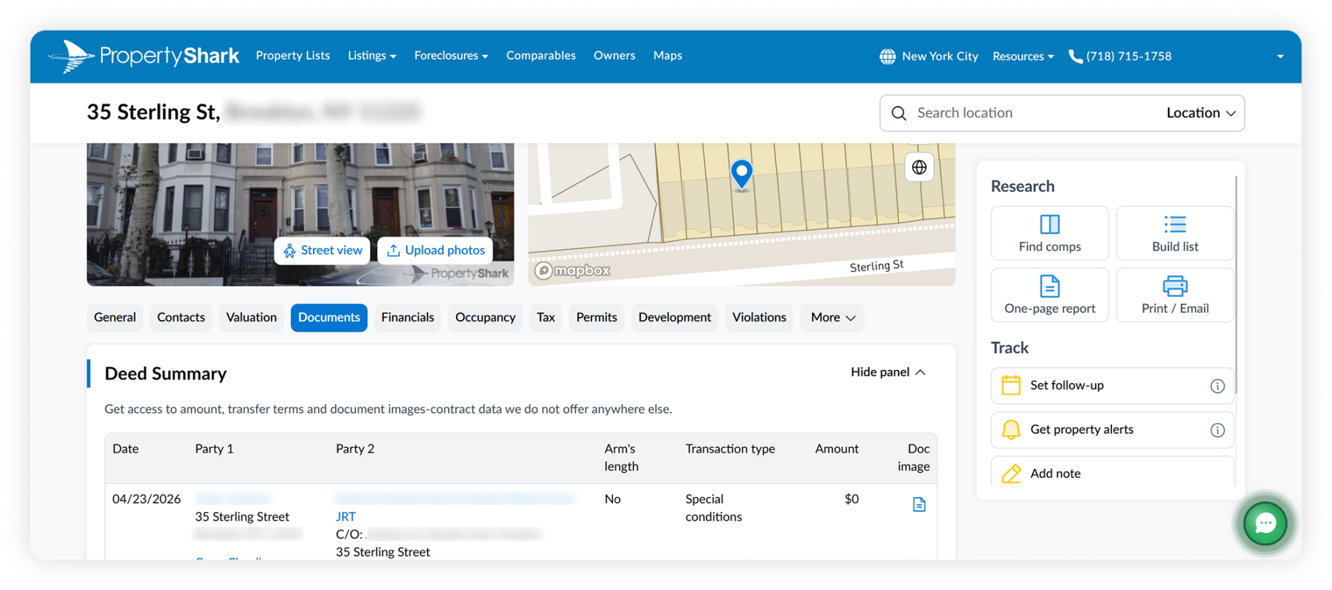
Where to get it: PropertyShark or a similar database make for the easiest and quickest ways to verify deeds and legal property descriptions, based on accurate, verified information.
2. Plat or Subdivision Map
If the parcel is in a recorded subdivision, the plat is often the quickest way to understand the lot. A plat or subdivision plat is prepared by surveyors, approved through the planning process and then recorded with the county recorded to establish clear bounds for legal transactions. It normally shows subdivision boundaries, lots, lot numbers, setback lines and easements.
Where to get it: The county recorder/clerk, archives or the local planning/public works records portal. If you are using an assessor copy, remember that some counties explicitly say the online assessor copy is informational and not the official recorded plat.
3. Recorded Surveys
A survey is the most direct record of where a surveyor found or reestablished the line. A survey typically contains the legal description, including bearings and distances, and can be used to prove the legal boundaries of a property. However, not every survey is recorded. If a plat/survey was recorded, you can get it from the clerk’s office; if it was not recorded, it may still be in the homeowner’s closing papers.
Where to get it: Start with the recorder/clerk if the survey was recorded. Then, check the title/closing package, seller files, lender/title company records or the surveyor who prepared it.
How to Do On-Ground Recon (Approximate Only)
If your goal is to walk the lot and gather data, use your county viewer or a parcel-overlay tool on your phone and follow the approximate line on the ground. This is useful for spotting fences, driveways, streams, tree lines or likely corner areas before you pay for a survey. However, remember that all these findings are approximate.
Look for corner monuments such as iron pins, pipes, disks, concrete markers or other referenced monuments. Monuments control property and boundary locations on the ground, and disturbing them can create costly problems. Make sure not to pull, bend, cover or move a monument.
Why the field walk is only approximate: Parcel geometry can be generalized; imagery can be slightly misaligned; county maps can lag behind recent deed changes or splits; and assessor maps are not survey products. That is why on-ground recon can help you get close but won’t settle a legal question.
When You Must Hire a Surveyor — And What You Get
A licensed land surveyor is needed when the answer needs legal weight. Good examples include:
- Building a fence, shed, garage, deck, retaining wall or addition near a line
- Resolving an encroachment or neighbor dispute
- Preparing a subdivision
- Filing survey plans with public officials
According to New York’s Office of the Professions, licensed surveyors perform boundary surveys, help determine whether one property encroaches on another and lay out subdivision lots It also notes that public officials generally require surveying plans stamped and signed by a licensed land surveyor.
A proper boundary survey is more than a map screenshot. Official standards describe deliverables such as research, field survey work, monumentation/marking, a survey map or plat, legal descriptions and a surveyor’s report. A survey is typically defined as a legal document signed by a licensed land surveyor that shows, at minimum, property lines, monument locations, dimensions and structures.
Only a licensed land surveyor can legally determine or reestablish the line for construction, permitting or dispute purposes. Boundary or land surveyors determine the legal land property lines and the exact locations of real estate and construction projects.
FAQs
Can I find a land boundaries map for free?
Yes, but often only approximately. Start with your county assessor or GIS parcel viewer to pull a parcel outline, APN/parcel ID and related assessment data. You can also check your county recorder/clerk for deeds, plats and any recorded surveys. Just remember that free web maps are typically informational and are not a substitute for a survey.
How accurate is PropertyShark?
PropertyShark is a research tool, not a legal survey. Its reports combine verified public record data, deed information and other official/governmental sources, but data depth varies by market and map layers are still best treated as orientation and due-diligence tools. Use PropertyShark to research boundaries, deeds, lot size, zoning and ownership, but use a licensed surveyor when the line must be legally defensible.
How do I read my deed or plat versus the map?
Use the deed and recorded plat or survey as the controlling records and check the web map for orientation. If your deed is metes and bounds, match the bearings, distances, calls and monuments to the survey. If it is a lot-and-block description, match the lot and block to the recorded subdivision plat. Do not treat the web map alone as the legal answer.
When should I call a surveyor?
Call a surveyor before construction near a line, when a permit or public filing requires a survey, when you suspect an encroachment or when you are subdividing or conveying land and need a legally reliable boundary. That is especially important for fences, decks, sheds, retaining walls additions and other improvements that could cross a line or setback.
Access comprehensive property data and ownership information with intuitive research tools.

Laura Pop-Badiu is a Senior Creative Writer at PropertyShark, with a degree in Journalism and a background in both hospitality and real estate. Laura is a certified bookworm with a genuine passion for the written word and a keen interest in the real estate market, having previously written for Yardi's RentCafe, CoworkingCafe and CoworkingMag. Her work has been featured in major publications like The New York Times, Forbes, NBC News, The Business Journals, Chicago Tribune, MSN and Yahoo! Finance, among others.
Recent Reports

NYC Resale Gains & Losses: Every Borough Made Money in 2025, Except Manhattan
In 2025, NYC home-sellers mostly made money. But, in Manhattan, resales came with losses — and it was apartments and recent buyers that absorbed them.

World Cup or Your Mortgage/Rent? Ticket Prices Rival Host City Housing Costs
World Cup ticket prices rival monthly housing expenses in the 11 U.S. host cities, with even the cheapest seats covering weeks or even months of rent or mortgage payments.

Locked-In Owners, Mobile Renters: Homeowners Stay Put as Renters Move 3.7x More Across Largest U.S. Cities
Renters became the primary drivers of long-distance mobility across the largest U.S. cities, moving 3.7 times more than owners in 2024, as high mortgage rates and housing costs kept many homeowners in place.